Work with 3D Map
Accordance makes it fun and easy to create a 3D projection of any part of the Atlas, and navigate around it.
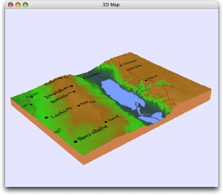
Open a 3D MapOpen a 3D Map
- Zoom in on a part of the 2D Map tab to the desired approximate magnification.
- Drag the mouse to draw a marquee box around the area of interest.
- On the Atlas tab, click the 3D Map button (
 ) and select the vertical magnification from the 3D Map pop-up menu.
 - Available vertical magnifications are 1x, 2x, 4x, 8x, 16x, and Auto.
- If selected, Auto will pick the vertical exaggeration amount based on the selection size.
- The higher the magnification, the more prominent the hills and valleys appear.
- Choose a higher magnification for a larger geographical area, and a lower magnification for a smaller area; this helps prevent the features from being overly exaggerated.
- To open the 3D map without any layers, press

A 3D map appears in its own window. The sides of the "cut" are colored brown; the features and layers currently selected on the map cover the altitude projection.
Print and SavePrint and Save
You can print the image or save it as an image file just like the 2D Atlas tab, by choosing the appropriate commands from the File menu.
The 3D Map window can be duplicated, saved, and recalled like other Accordance tabs.
3D Resolution3D Resolution
The degree of topographical detail shown in the 3D map depends on the geographical size of the area selected, not on the current scale of the 2D map from which it is derived. Therefore, if you select just the area of the Sea of Galilee, the 3D projection appears the same independent of the scale of the 2D Atlas; however, if you select the entire Mediterranean Sea, correspondingly less detail is displayed.
How Map Layers are Display on 3D MapsHow Map Layers are Display on 3D Maps
Display of layers on the 3D map depends on the type of layer applied to the map.
- Site Layers
- As you zoom in the 2D map, more site names appear and the names and markers get relatively smaller. Site layers are displayed in 3D exactly as they appear in your selection on the 2D map.
- To see more sites and smaller site names in 3D, zoom in on the 2D map tab before selecting the area for the 3D map.
- Region Names
- On 2D maps the sizes of region names relative to the map do not change as you zoom in, but more names do appear.
- More region names may also appear if you select a small area of the 2D map tab for the 3D map.
- Routes and Region Borders
- The routes and region borders are a fixed pixel width on the 2D map.
- On 3D maps the lines are redrawn and may be thinner.