Set Atlas Display Dialog Box
Prerequisites for use: An Atlas map is the active![]() The application, window, tab, or other screen element which is currently being used; sometimes called the "front" or "frontmost" screen element tab.
The application, window, tab, or other screen element which is currently being used; sometimes called the "front" or "frontmost" screen element tab.
Use: The Set Atlas Display dialog box is used to set the display for the active Atlas tab. If you save the tab on its own or as part of a saved workspace or session![]() The arrangement of screen elements when working with Accordance, the changes apply to the reopened Atlas tab.
The arrangement of screen elements when working with Accordance, the changes apply to the reopened Atlas tab.
Description: The options in this dialog box are the same as those in the Atlas Tab Display area of the Preferences dialog box. Note, however, that as stated above, the settings affect only the active Atlas tab. If desired, click Use as Default to have your changes applied to the Atlas tab whenever it is opened. (The changes are automatically added to the Atlas Tab Display area of the Preferences dialog box).

Open the Set Atlas Display Dialog BoxOpen the Set Atlas Display Dialog Box
- Open the Atlas and make it the active tab.
- Do one of the following:
- Right-click within the Atlas tab and choose Set Atlas Display.
- Press
 +
+ - On the Display menu, choose Set Atlas Display.
Set the Atlas Display (Overview)Set the Atlas Display (Overview)
- Open the Set Atlas Display dialog box.
- Choose the type of labels for which you want to set display characteristics.
- Choose the Font, Color, Scale, and Style for the label type.
- If desired, select a different label type to set its display characteristics.
- Choose the type of animation you prefer and whether or not to display rivers.
- Choose the default tool when you amplify
 To select words or a reference and search for the selection in the text or tool of your choice. You can select the resource in the Library or Amplify menus. A triple-click is a shortcut which amplifies to the top tool of the relevant category. from an Atlas name to a tool.
 - Click OK to save your changes.
Remember, these changes apply only to the active Atlas tab. - If you want these changes applied to all future Atlas tabs, click Use as Default. A message appears asking if you want to save the current settings as the default. Click Save to save the new default or Cancel to leave the current default unchanged.
Options in the Set Atlas Display Dialog BoxOptions in the Set Atlas Display Dialog Box
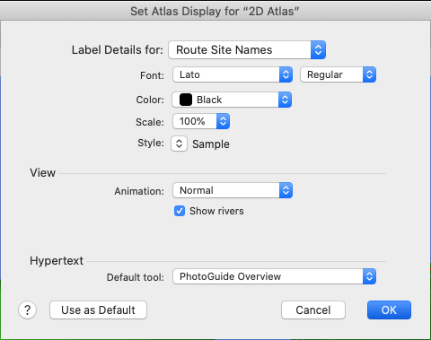
Label Details for pop-up menu: Used to select the types of labels to which your changes apply. After choosing the label type, you can then set the Font, Color, Scale, and Style for the label. You can have different settings for each label type.
- Route Site Names: Settings affect labels which appear along with the Route layers.
- Region Names: Settings affect labels which appear in the Region layers.
- Extra Site Names: Settings affect the site name labels displayed on a map when you Shift+Click on a map name, or use Find to locate a site on the Atlas.
- Extra Region Names: Settings affect the region name labels displayed on a map when you Shift+Click on a map name, or use Find to locate a region on the Atlas.
Font pop-up menu: Choose from any system font.
Color pop-up menu: Choose from a range of colors.
Scale pop-up menu: Choose the size (in percent) relative to other name labels. This pop-up menu is dimmed when Region Names or Extra Region Names are selected, since those labels are tailored to a specific item and cannot be modified.
 Style pop-up menu: Choose from any of the standard styles in Accordance. The word Sample is displayed with the currently selected style. To remove a style select it again from the pop-up menu, or choose Plain Text to remove all styles.
View Area: These options affect how routes and rivers are displayed.
- Animation pop-up menu: Choose the type of animation to be used for routes.
- Normal: Displays the entire route in faded colors, then draws intense color over the route from start to finish.
- Continuous: Runs the animation in a continuous cycle. You can pause and restart the animation using the Animate option at the top of the Atlas tab.
- No Faded Route: Draws only the intense color over the route, without pre-drawing the entire route; you have to wait to see where the route goes.
- Continuous No Faded Route: Runs the animation in a continuous cycle without a faded route.
- Show Rivers: When selected, rivers are displayed on the Atlas.
|
Hint Hiding rivers speeds up full Atlas display. |
Hypertext area: This option determines what tool opens when you amplify from an Atlas to a tool.
Default tool pop-up menu: Opens a list of all available tools. When you double-click an Atlas name the selected tool opens in a new tab.
|
Hint The PhotoGuide Overview or Place Names Tools work well here. |
Use as Default: Saves your changes as the default for all subsequently opened Atlas tabs.