Measure Atlas Distances
The Instant Details displays the elevation and exact coordinates of the place under the cursor. The elevation and coordinates update as the cursor is moved over the Atlas. The Instant Details shows the latitude, longitude, and UTM grid coordinates throughout the map area. The local Israel coordinates appear when the cursor is in an area covered by Israeli maps.
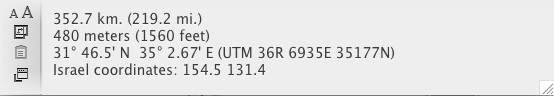
You can also measure and display the distance between two points on an Atlas tab. The distance is displayed in the Instant Details as well as on the top right of the Atlas tab.
To measure distances between points on the Atlas tab:
- Make sure the Atlas tab is active
 The application, window, tab, or other screen element which is currently being used; sometimes called the "front" or "frontmost" screen element.
 - Hold down on Alt. The cursor changes to a plus sign.
- Click on the first point on the map.
- With Alt still held down, move the cursor to the next point on the Atlas. As the cursor moves a line is drawn over the map; the distance from the first point to the next point is continuously updated in the Instant Details.
-
- Release Alt and click to stop measuring.
